|
A Guide to Managing and Maintaining the Street Centerline File for Johnson County
Why Read This?
The purpose of this report is to document the creation, maintenance,
and attributes of the street centerline file. Methods and processes for maintenance
will be explained in order to keep the file accurate and up-to-date. The
countywide street centerline file was developed in the fall of 1994 with
the coordination of MED-ACT and AIMS. Its uses are many. Anything from school
district boundaries, to vehicle routings, to address matching applications
are benefiting by this countywide file. The maintenance of this file is
critical to its continued value.
The most important thing to take away from this document is:
If you find any discrepancies or errors while using the street centerline file or in
viewing maps or presentations that contain the street centerline file please
contact AIMS or email
.
Who Should Read This and How Will It Help You?
This information is for use by the AIMS, its partners and others
who have a need for communicating or using information related to streets and
addresses in Johnson County. The street centerline file has uses ranging from
emergency dispatch, and real time vehicle routing and tracking, to public
information systems and many others. The benefits of a standardized, countywide
street centerline file are numerous.
The following have been identified as possible users of the street centerline
file. Anyone working in one of the occupations below should be familiar
with this report. Their familiarity and participation will assist in making
this the most accurate file possible.
- Planning
- Engineering
- MED-ACT
- Police
- Fire
- ECC
- Emergency Mgmt.
- Pavement Management
- Map Sales
- Internal Mapping Analysis
- Routing Snow Plows, Delivery vehicles, Maintenance Crews, Bus Routing
- Schools
- Election Commission
- Dispatch Services i.e. utility companies
- Permitting Applications i.e. utility companies
- Address Assignment
- Public Kiosk and/or Internet/Intranet Applications
How Was the File Created?
The street centerline file project was started in 1994. Analytical Survey
Inc. (ASI) from the planimetric coverages provided the file's original
creation. Subsequently, heads-up digitizing and plat centerline arcs were
copied into the street network file to fill in areas built after the planimetrics
were flown.
Topology errors were corrected, street names were added and classification
codes for street type were added. Since that time the arcs in the file
have been maintained by the AIMS staff receiving information about changes
from many sources. Primarily changes have been provided from an individual
in Med-Act who distributes hand drawn changes to the maps and copies them
to their vehicle drivers. Most recently steps were implemented to provide
Med-Act drivers with AIMS maps showing the streets and parcel boundaries
to emphasize areas of new development.
Address ranges were the next step to enhancing this file. A county-wide
parcel point coverage was used with the Arc/Info NEAR command to identify
arc segments closest to each parcel centroid. The parcel centroid road
NAME was then compared with the centerline road NAME and DIRECTION AND TYPE
were compared. A score was assigned to each arc and any score not matching
the specified range had to be manually checked and corrected. An Arc/Info
routine provided by Black and Veatch was used to assign the initial address
ranges to each arc. These address ranges were then "massaged" to meet specific
criteria. Address matching was performed using the 911 intersection data for
further quality control. Overlapping ranges, missing or incorrect road names, missing address ranges,
and verification against the countywide address point dataset are added as part of
the ongoing QC process.
Accuracy
The street centerline file has an estimated spatial accuracy of + or
- 5 feet on 98% of the arcs. The other 2% are road modifications like widenings
or relocations that aren't well documented. The tolerance on these are
estimated at + or - 10 feet. This information is based on our partners’
experience using the file and information that Blue Valley School District
provided where they had actually done some field checks, for bus routing
purposes and found the file to be very accurate. It is the goal of the
AIMS project to maintain this accuracy and to work towards 100% accuracy.
The attribute data accuracy is dependent on the attribute item. Currently
address ranges are estimated to be 80% accurate, speed limits are only
70% accurate. Road_name, oneway, minutes, f_elev and t_elev are estimated
to be 80% accurate. These percentages will increase over time as more people
access the file for their applications and report inaccuracies, errors
or omissions.
File Maintenance Methods and Processes
This section will focus on giving general descriptions to the overall
street file maintenance as well as some specific information regarding
who to contact, and why certain things are done.
Communicating updates
"StreetInfo" is a generic email, courier stop, and post office
address that is managed through AIMS. Information can be sent to "StreetInfo"
via:
-
Email:
- Inter-County courier: Name - StreetInfo Department - DTI-AIMS
-
U.S. mail address:
Johnson County AIMS
111 S Cherry St, Ste 3100
Olathe, KS 66061
Attn: StreetInfo
Streets from Plats
The County Clerk’s office digitally re-creates the plats by using coordinate
geometry for incorporation into the AIMS datasets. The centerlines of these
plats are then added to the centerline file by heads up digitizing what looks
like the centerline in any of the Right of Ways. Attributes for these
centerlines are then added based on what the plat says, and some review
processes.
The arcs heads up digitized because the original method of construction,
coordinate geometry of the parcels, does not fit with the topology in the
published street centerline file. In a plat every road can be many arcs that
make up a section of street. In the published street centerline file, there are
fewer individual arcs that make up a road. For additional information on the
process of adding arcs to the street centerline file please contact
.
Streets in new plats are being entered into the file as soon as the
property is entered, however they are coded as unbuilt until they are confirmed
as built. Public Works uses a database that tracks new plats being filed, the city in which the
plat will be built, and the road names in the plat.
December 1 every year a letter is generated by Public Works for the
respective cities, asking them to confirm if the roads listed in the letter
had been built or not. This letter will ask that the cities respond to
"StreetInfo" mail stop and ask for confirmation that the plat
was finished and that all the streets within the plat have been built.
If the city responds that it is built then an inspection is done of the
street centerline file to be sure it was added. Any changes in the plat
from the time it was filed should be reported back, especially road name
changes. On top of this AIMS works with a contact in the Med-Act office to
visually confirm whether streets have been built or not, and to confirm the
names with any street signs that may be present also.
"StreetInfo" will copy Public Works with the responses and
see that the roads are included in the street centerline file with the
appropriate attributes. This information will be incorporated into the
street file by mid-January. This is to allow Public Works adequate time
to produce their County Engineer's Road Map by the end of January.
Realignments and Road Improvements
Currently, Overland Park submits letters to MED-ACT and others with
street update information. These documents include address changes, road
name changes, etc.. The information is extremely valuable and other cities
maybe doing something similar. Our goal is to have all the cities provide
the County with the same type of information. This information should be
sent to "StreetInfo". At this point copies will be made and provided
to MED-ACT and others within the County who have an interest. This information
is then used to update the street centerline file.
The current process of obtaining street data from MED-ACT will be continued.
Presently, crews have pages of a map book assigned to them to check at
least twice a year for accuracy. This equates to approximately a page a
week from each crew. The pages with corrections are then turned in to the
mapping staff in MED-ACT who gives copies to AIMS. A method will be put
into place to assure us that the checks are being done on a regular basis.
Right now there is no follow up. Each crew understands the importance of
knowing the status of their service area. Therefore, it is assumed that
each crew is acting responsibly, reporting any changes to the mapping staff
and to actually check their service area at least twice a year.
Road Closings
MedAct is informed of all road closings in Johnson County. They will
copy StreetInfo with this information in order to update the street centerline file.
Attributes
This information will be as accurate as you and the other users want
to make it. Submitting changes and corrections to StreetInfo is the county’s
primary source for getting updated information. This is an ongoing process
and we solicit everyone’s help in identifying incorrect or missing data. The
other source of getting updated information is through the Address Point Dataset.
The county has scripts that run nightly to basically verify that all of the
address points in the county fall within the address range on a street segment,
and that they are named exactly the same.
Annotation
Annotation in the street centerline file is important because it is
the method for effective communication of street names in map display.
Adding annotation to the street centerline file is limited to
a couple of individuals who have had a great deal of experience in determining
effective/efficient placement of road names on the arcs. Past experiments
with allowing multiple editors resulted in inconsistent editing which at
times had big impacts on the cartographic and topologic characteristics
of the street centerline file. There are many aspects to adding annotation
that have to be considered for example annotation needs to be added in
a manner consistent with the direction of the arc.
The level to which the annotation is added affects the display and usefulness
of the annotation. The level of the annotation in most cases corresponds
with the classification assigned to the road such as 10/local, 20/collector,
30/thoroughfare, and 40/highway. Additional annotation is added to arcs
at a level of 11, 21, 31, or 41 to accommodate Med-Act's need for maps that
display every arcs street name. A couple of other Annotation Levels are being
updated for Med-Act’s needs, 12-Address Ranges, and 13-Notes. Unlike some general use maps that only
need a majority of the roads annotated for cartographic display, Emergency
Services cannot afford to miss a street because it was not displayed on
the map to make it look appealing.
Street Centerline File Publishing
The updated street centerline file is copied to the published directory every
Friday evening by the AIMS staff. It can be published more frequently if the
need arises. This schedule corresponds with the updates to the property
attribute files and is sufficient for the centerline file’s current uses. The
file is published as part of AIMS weekly scheduled data publishing processes.
The Centerline file is currently being edited as SDE Geodatabase Feature Classes
with some custom tools in the current version of ArcMap. The goal is to have the file updated
daily when real time access and/or tracking is necessary.
What Happens in the ArcMap Code?
Whenever a centerline segment is added, updated, or modified, the code runs
through some different modules that calculate specific attribute fields. When a
new segment is added, the code assigns it a UNIQ identifier based on the date
and time it was entered. The UNIQ also uses a two digit random number to ensure
that it is not duplicated. Altough this can produce duplicate UNIQ’s, the
chances of two people entering a segment at the same second and getting the same
random number is reasonably small. Also the Modified, Date Added, Minutes,
Miles, Left and Right City, State, Zip, and County fields are automatically
calculated/updated. The ROAD_NAME field is automatically re-concatenated when
any of the parts are changed.
Database Design
The following are the items that make up the info table for Centerline_LN:
| Item Name |
Width |
Output |
Type |
Description |
| OBJECTID |
- |
- |
INT |
System generated |
| SUB_CLASS |
- |
- |
INT |
Classification of the segment |
| ST_STATUS |
- |
- |
INT |
Status of the road surface |
| ST_RESP |
- |
- |
INT |
Maintenance Responsibility of the segment |
| PREV_UNIQ |
- |
- |
DBL |
Most Previous UNIQ Number |
| UNIQ |
- |
- |
DBL |
Unique Identifier |
| MODIFIED |
- |
- |
DATE |
Date segment last modified |
| ROAD_NAME |
71 |
71 |
TXT |
Concatenated street name |
| PRE_DIR |
2 |
2 |
TXT |
Prefix direction |
| STR_NAME |
60 |
60 |
TXT |
Name only |
| STR_TYPE |
4 |
4 |
TXT |
Street type |
| SUF_DIR |
2 |
2 |
TXT |
Suffix direction |
| L_ADD_FROM |
- |
- |
INT |
Left address at from node |
| L_ADD_TO |
- |
- |
INT |
Left address at to node |
| R_ADD_FROM |
- |
- |
INT |
Right address at from node |
| R_ADD_TO |
- |
- |
INT |
Right address at to node |
| ONEWAY |
2 |
2 |
TXT |
Oneway status |
| SPEED |
- |
- |
INT |
Speed limit |
| MINUTES |
- |
- |
FLT |
Time impedance |
| MILES |
- |
- |
DBL |
Calculated length in Miles |
| F_ELEV |
- |
- |
INT |
From elevation |
| T_ELEV |
- |
- |
INT |
To elevation |
| DATE_ADDED |
- |
- |
DATE |
Date the segment was added |
| L_STATE |
15 |
15 |
TXT |
State to the Left |
| R_STATE |
15 |
15 |
TXT |
State to the Right |
| R_ZIP |
- |
- |
INT |
Zip code to the Right |
| L_CITY |
15 |
15 |
TXT |
City to the Left |
| R_CITY |
15 |
15 |
TXT |
City to the Right |
| L_COUNTY |
15 |
15 |
TXT |
County to the Left |
| R_COUNTY |
15 |
15 |
TXT |
County to the Right |
| MODTIME |
17 |
17 |
TXT |
Modified date and time string |
| LASTUSER |
20 |
20 |
TXT |
Last person to update |
| ST_CLASS |
- |
- |
INT |
10’s position of SUB_CLASS |
| SHAPE |
- |
- |
GEO |
Stores the geometry |
| SHAPE.len |
- |
- |
DBL |
System calculated length |
Table 1 - Centerline_LN Database Item Definitions.
The following section defines the possible values that can be found in each
of the items of the Centerline_LN file:
SUB_CLASS: This is a method for classifying the roads into certain categories.
An attempt was made to design the classification scheme in order to meet
the needs of the majority of our partners. This breakdown is the result:
| 10 | Local - Unclassified |
| 11 | Local - Public |
| 12 | Local - Private |
| 13 | Local - Access |
| 18 | Local - Temporary Code |
| 19 | Local - Mono Parity |
| 20 | Collector - Unclassified |
| 21 | Collector - Minor |
| 22 | Collector - Major |
| 30 | Thoroughfare - Unclassified |
| 31 | Thoroughfare - Minor |
| 32 | Thoroughfare - Major |
| 39 | Thoroughfare - Ramp |
| 40 | Highway - Interstate |
| 41 | Highway - State |
| 42 | Highway - US |
| 49 | Highway - Ramp |
| 99 | Reserved - Dual Centerline |
Table 2 - SUB_CLASS codes and descriptions.
ST_STATUS: The current purpose of this item is to identify streets that have
been Build or Unpaved versus Unbuilt roads. 95% of the arcs in the centerline file
are coded as built. The Classification Unbuilt is used mainly for display
purposes to allow users to see that there is a planned road that will be there,
but it is not drivable as of yet.
| Code |
Classification |
| 0 |
Unbuilt |
| 1 |
Built |
| 2 |
Unpaved |
Table 3 - ST_STATUS codes and descriptions.
PREV_UNIQ: The unique number previously assigned to an arc before it
was modified
UNIQ: A unique number that is assigned sequentially to the arcs. This
number is provided for analysis purposes and to link the arcs to external
databases for uses such as pavement management.
ROAD_NAME: This item includes the entire road name for an arc such as:
W 132nd St or N Lakeshore Dr E.
PRE_DIR: This item is populated with the first direction of the entire
street name. In the examples above under ROAD_NAME the PRE_DIR is W and N. The
possible values are N, S, E, and W
STR_NAME: This is the name of the street only. In the examples above
this item is populated with 132nd and Lakeshore
STR_TYPE: This identifies the type of street. In the examples above
this would be St and Dr. The possible values are AVE, BLVD, CIR, CT, DR,
HWY, LN, PKWY, PL, RD, RDWY, ST, TER, and WAY.
SUF_DIR: This field is not used often, but in the example of N Lakeshore
Dr E the E is the SUF_DIR. The possible values are N, S, E, and W.
L_ADD_FROM: The address assigned to the left side of the beginning of
an arc. This field is used for address matching and matches the naming
convention in Arcview. See Illustration 1 for an example.
L_ADD_TO: The address assigned to the left side of the end of an arc.
This field is used for address matching and matches the naming convention
in Arcview. See Illustration 1 for an example.
R_ADD_FROM: The address assigned to the right side of the beginning
of an arc. This field is used for address matching and matches the naming
convention in Arcview. See Illustration 1 for an example.
R_ADD_TO: The address assigned to the right side of the end of an arc.
This field is used for address matching and matches the naming convention
in Arcview. See Illustration 1 for an example.
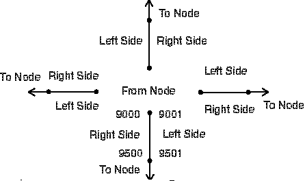
Illustration 1 - Left and right address range examples for from nodes and to nodes.
ONEWAY: Streets that are one way in nature. (For example: highway ramps).
Values:
FT - Direction goes from the FROM-NODE to the TO-NODE.
TF - Direction goes from the TO-NODE to the FROM-NODE.
N - The segment is closed to either direction.
2 - The segment can be traversed in either direction.
SPEED: A number that represents the speed limit of a street. If it is a new
segment this is a best guess based on each segment’s classification, these may be updated
if needed by submitting the change to StreetInfo. All new street segments
have a speed assigned to them using the following schema:
| Code |
Classification |
Value in MPH |
| 10 |
Local |
25 |
| 20 |
Collector |
35 |
| 30 |
Thoroughfare |
45 |
| 40 |
Highway |
65 |
| 49 |
Ramp |
25 |
Table 4 - Speed Classifications and Values.
It is our goal that posted speed limits will be assigned to arcs in
the future, but this is the type of information we would need to have sent
to us by you. Any method you have for identifying posted speed limits would
be useful to us. Please send this information to StreetInfo.
MINUTES: The time it should take to traverse the segment based on LENGTH
and SPEED. The time is stored as decimal minutes; thus, 30 seconds is represented
as 0.50.
F_ELEV and T_ELEV: A value of 0 or 1 is assigned to the node at either
end of an arc. This coding helps to identify segments that pass over other
segments (i.e. overpasses) in networking applications. This tells the Network
Analyst application that it can't get off of an arc with a node value of
0 and move to an arc that has a node value of 1. The following diagram
illustrates how values would be assigned for an overpass:
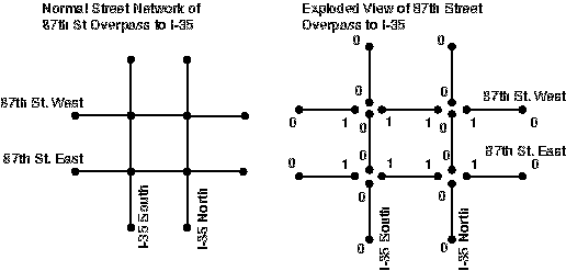
Illustration 2 - F_ELEV and T_ELEV node assignments.
ST_CLASS: This is a redefined item for Arc/Info users. It is derived from SUB_CLASS.
| Code |
Classification |
| 1 |
Local |
| 2 |
Collector |
| 3 |
Thoroughfare |
| 4 |
Highway |
Table 5 - ST_CLASS codes and values.
L_CITY and R_CITY: Arcs are not broken at city boundaries, unless requested. However, city names are
added to each arc. Whichever city spatially contains the center point of the
arc with an offset of two feet Left and Right will be assigned to the arc. If the arc is primarily in
the unincorporated area of the County (not in a city), then the value of County is assigned
to the arc. The following are the possible values to be assigned to each arc:
- Bonner Springs
- County
- DeSoto
- Edgerton
- Fairway
- Gardner
- Lake Quivira
- Leawood
- Lenexa
- Merriam
- Mission
- Mission Hills
- Mission Woods
- Olathe
- Overland Park
- Prairie Village
- Roeland Park
- Shawnee
- Spring Hill
- Westwood
- Westwood Hills
L_ZIP R_ZIP: Zip code attributes are assigned to the arcs in a manner similar
to city name. The following are valid values:
| ZIP Codes |
| 66013 |
66018 |
66019 |
| 66021 |
66030 |
66031 |
| 66051 |
66061 |
66062 |
| 66063 |
66083 |
66085 |
| 66201 |
66202 |
66203 |
| 66204 |
66205 |
66206 |
| 66207 |
66208 |
66209 |
| 66210 |
66211 |
66212 |
| 66213 |
66214 |
66215 |
| 66216 |
66217 |
66218 |
| 66219 |
66220 |
66221 |
| 66222 |
66223 |
66224 |
| 66225 |
66226 |
66227 |
| 66251 |
66282 |
66283 |
| 66285 |
66286 |
|
MODIFIED: This item was added after the street file was originally created.
It is used for historical tracking, change analysis and for recovery purposes.
All arcs existing at the time the item was added were given the value of
11-2-97. Whenever a segment is modified or updated this date is populated with
the current system date.
Any Questions?
Should you have additional questions concerning the Street Centerline
file please contact AIMS or email
.
|