|
What is LIDAR?
LIDAR is an acronym for LIght Detection And Ranging.
It is a remote sensing method that uses light in the form of a pulsed laser to measure variable distances to the Earth.
Lidar is commonly used to make high-resolution maps, with applications in surveying, geography, hydrology, forestry, and many others.
LIDAR is available from AIMS in a variety of formats. The most popular of these is as a Digital Elevation Model (DEM). DEMs are available as ArcGIS Image Services via AIMS Online.
LIDAR is also available for download via Digital Data Request (DDR).
When specifiying what data to receive, make sure the planimetrics check box is checked, and you will then have the option to request LIDAR data.
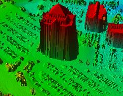 3D Elevation All Returns
|
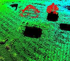 3D Elevation Points
|
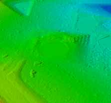 3D Elevation Bare Earth All Returns
|
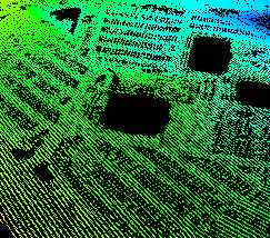 3D Elevation Bare Earth Points
|
When was the Johnson County LIDAR flown?
New LIDAR data was captured for Johnson County in December 2020. Previous flights occurred in 2012 and 2006.
Johnson County LIDAR Specifications and Accuracy
LIDAR data was captured at a nominal post spacing of 1.0 meter (3.2 feet). Tiles are 5,000 X 5,000 feet. First, Middle and Last returns were delivered in LAS files.
Filtering to bare earth should meet the following standards:
- 90% of artifacts removed.
- 95% of outliers removed.
- 95% of vegetation removed.
- 98% of buildings removed.
For a full description of specifications and data accuracy, please see the LiDAR Flight Report: Johnson County 2020 Lidar Flight Report.
What Format is the Data in?
Johnson County received the data in LAS format, which is a binary file that is the industry standard. Johnson County redistributes the data either as a DEM (.tiff), or as .las and .xyz files. If you have questions about access to any of the data formats, please let us know by contacting the mapper of the day.
What types of applications is LIDAR data used for?
The most common use of LiDAR data is to create Digital Elevation Models. DEMs are frequently used for floodplain delineation and mapping, aerial photography orthorectification, breakline generation, and contouring. In addition, prior-year DEMs can be compared with the current DEM for change-detection. This has been used in Johnson County to identify areas of stream erosion/sedimentation, new construction, and tree canopy loss.
How large is the data?
There are 2 ways to measure the size of the data: disk space required and volume of points. A typical 5,000 foot tile contains approximately 27.5 million points, and consumes about 1 gigabyte in disk space. For the entire county, we estimate that there are approximately 19.3 billion points, consuming 580 gigabytes in disk space.
What future plans does Johnson County have for LIDAR?
Johnson County LIDAR data has been updated on a 6-to-8 year timeframe. We will continue to evaluate its usefulness prior to any future flights, and we greatly value your feedback. Please let us know your thoughts by emailing the mapper of the day.
Where can I learn more?
Reference
|